Walk with landscape-reactive sashes: Gretton, Brookfield Plantation and Rockingham
A collation of data, documentation and discussion for participants of the walk around Gretton, the Brookfield Plantation and Rockingham that took place on the 6th of May…
Walk leader David Craddock from the Ramblers was kind enough to let us infiltrate his 8 mile walk with the landscape-reactive sashes.
This was the first outing for the sashes and also the first time I had used my differential GPS set-up in a rural landscape, so quite a step into the unknown…
So many people had volunteered to wear sashes that there was none for me to wear, so my feedback on how things were working was mostly done by quizzing people as we walked or listening carefully to try and hear the buzzes!
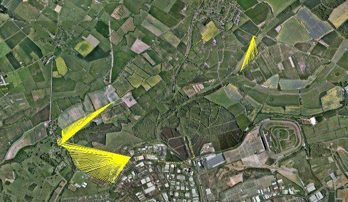
Here is a screenshot of my traces from the morning overlaid onto Google Earth.

It was a long route, so the lines don’t really show up at this level of zoom, except for the ‘major incidents’…
Starting clockwise from the top, the first spray of lines is fairly apt, as this marks the spot where one of my GPS modules fell off! It was some time before I noticed, and a while after that before, retracing our steps, we eventually found it submerged in a muddly puddle. Many, many thanks to the lady (Karen?) who came back with me to help me look. She also donated some tissue for the clean-up and, miraculously, a few minutes later the module was dried off, plugged in and working again. Phew!
My lines disappear as we enter the Rockingham Plantation; not due to interference, but the slightly more mundane reason of the battery running out! Although this was spotted pretty quickly, it was some time before the logging commenced again and, since we were still hot-footing it to try and catch up with the rest of the group, we covered quite a lot of ground in that interval.
The sight below was a very welcome one and made that much sweeter by the flecks of yellow from the sashes and the cries announcing that they had suddenly resumed buzzing as I came back into range!
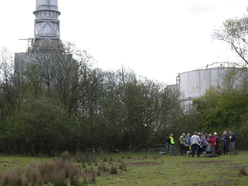
The above point also marked the transition of the walk from rural to urban landscape as our route skirted along the edge of industrial parks on the outskirts of Corby. If you click through to the original – and slightly larger – image you can just about make out that at this point the lines get a bit longer.
Each line represents where my two GPS modules think they are at a moment in time – one end of the line is one module, the other end the other module. Therefore, the more they disagree, the longer the line is.
Out in the open, the modules get a pretty much direct line-of-sight connection to the signals coming from the satellites – the modules calculate similar positions and the lines are very short. (The sashes would have given a few short, weak buzzes.)
As we make our way through the large warehouses and factories, however, the GPS signals are more likely to reach the modules by indirect routes, bouncing off the buildings en route. The extra amount of time this takes affects the calculations of position. My lines get longer and your buzzes get more energetic.
As our route bends around to the left, something happens to cause one of my modules to lose its fix altogether. Here one end of the lines are fixed to a single point, whilst the other ends follow the route we walked. This happens again as we turn off the road onto the Jurassic Way (I think I changed batteries here.)
So, an interesting set of lines that tell a story, although it wasn’t what I set out to find out about! The lines from Charlotte’s logging device tell that particular story a lot better. Below are some excerpts (click on the images to see the original on Flickr), or you can download the .kml files, open them in Google Earth and have a good ol’ poke around. Part 1, Part 2.

Overview of the route taken (no major incidents!)

Smaller lines get bigger as the group enters the dense woodland of the plantation

Close-up of the lines produced when walking through the plantation - here it's obvious that the GPS modules think they're much further apart than they really are

The large buildings of the industrial units also produce long lines

Clusters of longer lines show where the group paused under trees to take turns crossing the stiles

The tunnel under the railway track

Leaving and entering Gretton village at both ends of the walk
So, some nice results there – both expected and unexpected!
I really liked how the group looked wearing their sashes and the resulting traces tell some interesting stories about the physicality of the landscape(s) we moved through.
You can try the GPS tag for more blog posts I’ve written relating to my work with GPS around the world, and the full set of my photos from this walk is at http://www.flickr.com/photos/nikki_pugh/sets/72157629978908541/with/7002887160/. Edited highlights here: http://www.flickr.com/photos/nikki_pugh/sets/72157629635144548/
Thanks to everyone who took part and to David for leading the walk.