29 Not-Quite-Random Walks Around Tokyo

I’ve been a bit slow in posting this one, but the audio and slides of the talk I did for Pecha Kucha Night Coventry in October has been put on the main PK website:

The explosion during slide 13 is courtesy of the party poppers left behind by an earlier speaker, Laura Elliot!

Follow @PKN_Coventry on Twitter to keep up-to-date with what’s happening with future events.

Super Critical Mass: Voices

A few hundred people in Manchester Cathedral.
Eyes closed; silent; sat quietly, standing still or walking slowly.

Super Critical Mass

20 or so of the assembled, dressed in black, each at a position midway between pillars, sung and intoned according to a simple set of rules which, when unfurled at the rate of the singer’s breath, ebbed, flowed, combined and separated to form something that was neither ordered nor chaotic.

There are audio recordings, but they do not do the experience justice…


Super Critical Mass: Voices was, for me, one of the highlights of the Future Everything festival.

[An] immersive and meditative performance-installation that articulates both instrument and architecture, within which audiences can freely move about or sit and absorb.

[…] a contemporary take on a number of traditions including the orchestra, homogenous ensembles, sound installation, community arts, and public art practice.

Torn between jumping up and whooping and sitting in meditative silence, our end-of-performance round of applause was somewhat shell-shocked and muted. A moving experience with added computation, aleatory processes and people being really brave to stand singing with an unseen crowd flowing around them.

Loved it.

Walk with landscape-reactive sashes: Gretton, Brookfield Plantation and Rockingham

A collation of data, documentation and discussion for participants of the walk around Gretton, the Brookfield Plantation and Rockingham that took place on the 6th of May…

Walk leader David Craddock from the Ramblers was kind enough to let us infiltrate his 8 mile walk with the landscape-reactive sashes.

This was the first outing for the sashes and also the first time I had used my differential GPS set-up in a rural landscape, so quite a step into the unknown…

So many people had volunteered to wear sashes that there was none for me to wear, so my feedback on how things were working was mostly done by quizzing people as we walked or listening carefully to try and hear the buzzes!

Here is a screenshot of my traces from the morning overlaid onto Google Earth.

Gretton Walk GPS traces

It was a long route, so the lines don’t really show up at this level of zoom, except for the ‘major incidents’…

Starting clockwise from the top, the first spray of lines is fairly apt, as this marks the spot where one of my GPS modules fell off! It was some time before I noticed, and a while after that before, retracing our steps, we eventually found it submerged in a muddly puddle. Many, many thanks to the lady (Karen?) who came back with me to help me look. She also donated some tissue for the clean-up and, miraculously, a few minutes later the module was dried off, plugged in and working again. Phew!

My lines disappear as we enter the Rockingham Plantation; not due to interference, but the slightly more mundane reason of the battery running out! Although this was spotted pretty quickly, it was some time before the logging commenced again and, since we were still hot-footing it to try and catch up with the rest of the group, we covered quite a lot of ground in that interval.

The sight below was a very welcome one and made that much sweeter by the flecks of yellow from the sashes and the cries announcing that they had suddenly resumed buzzing as I came back into range!

Walk with landscape-reactive sashes, Gretton

The above point also marked the transition of the walk from rural to urban landscape as our route skirted along the edge of industrial parks on the outskirts of Corby. If you click through to the original – and slightly larger – image you can just about make out that at this point the lines get a bit longer.

Each line represents where my two GPS modules think they are at a moment in time – one end of the line is one module, the other end the other module. Therefore, the more they disagree, the longer the line is.

Out in the open, the modules get a pretty much direct line-of-sight connection to the signals coming from the satellites – the modules calculate similar positions and the lines are very short. (The sashes would have given a few short, weak buzzes.)

As we make our way through the large warehouses and factories, however, the GPS signals are more likely to reach the modules by indirect routes, bouncing off the buildings en route. The extra amount of time this takes affects the calculations of position. My lines get longer and your buzzes get more energetic.

As our route bends around to the left, something happens to cause one of my modules to lose its fix altogether. Here one end of the lines are fixed to a single point, whilst the other ends follow the route we walked. This happens again as we turn off the road onto the Jurassic Way (I think I changed batteries here.)

So, an interesting set of lines that tell a story, although it wasn’t what I set out to find out about! The lines from Charlotte’s logging device tell that particular story a lot better. Below are some excerpts (click on the images to see the original on Flickr), or you can download the .kml files, open them in Google Earth and have a good ol’ poke around. Part 1, Part 2.

Overview of the route taken (no major incidents!)

Smaller lines get bigger as the group enters the dense woodland of the plantation

Close-up of the lines produced when walking through the plantation - here it's obvious that the GPS modules think they're much further apart than they really are

The large buildings of the industrial units also produce long lines

Clusters of longer lines show where the group paused under trees to take turns crossing the stiles

The tunnel under the railway track

Leaving and entering Gretton village at both ends of the walk

So, some nice results there – both expected and unexpected!

I really liked how the group looked wearing their sashes and the resulting traces tell some interesting stories about the physicality of the landscape(s) we moved through.

You can try the GPS tag for more blog posts I’ve written relating to my work with GPS around the world, and the full set of my photos from this walk is at http://www.flickr.com/photos/nikki_pugh/sets/72157629978908541/with/7002887160/. Edited highlights here: http://www.flickr.com/photos/nikki_pugh/sets/72157629635144548/

Thanks to everyone who took part and to David for leading the walk.

Fermynwoods residency: walking events

This weekend is that of the Corby Walking Festival and as part of my residency I’ve been commissioned to lead (or infiltrate) 3 events.

The first was on Saturday, when we took one of the Possibility Probes for a walk around the area by the Corby Cube – a mixture of town centre, great big architecture and a footpath through some woods.

Not much response from the probe until the swimming baths send it off the scale...

With mighty cold temperatures, squally showers and tuned-to-Birmingham settings that had worked well on our test walk but didn’t seem to be giving us much feedback now, we put up a bit of a fight but then conceded and headed to a cafe area in the Cube to look at the traces and have a good ol’ chat.

Annotated traces gathered on the Corby event - click for larger version

The second event was an 8 mile walk led by rambler David Craddock, for which I made some landscape-reactive sashes.

The weather was kind, there was a good bunch of people – many willing to don sashes – and the recalibrated code gave much better results. More discussion and results to follow, but here are a few images (courtesy of James Steventon, Fermynwoods Contemporary Art) in the meantime…

Mid-way pause and reunion

Concrete canyon, Gretton style

The group (and additions of yellow) make their way through the countryside

view from the top

We’ll be taking the sashes out again today for a 3 mile walk between Fermyn Woods Country Park and Lyveden New Bield.

Possibility Mapping (heavy object and built environment)

DSCN0184

  • It is only through our interactions/collaborations/experiments that we show up.
  • Change the assemblage and a different set of possibilities emerges.
  • Can we explore differently in order to reveal new possibilities?
  • Through the use of new tools, do we get a new world to interact with?
  • How do you arrive at the places that are not yet mapped?
  • Observations and questions arising from the Live Feeds research programme led by Spurse, NYC 2011


    Possibility Probe (heavy object and built environment)
    is a starting point for asking questions and conducting experiments. A direct response to the trend of making mobile technology smaller, lighter and more discreet; these objects are unwieldy, heavy and broadcast to all within hearing distance.

    Cumbersome – a burden if not shared – these Possibility Probes resonate with the built environment that they are carried through. Like a drum or a heart, they beat faster the more they are surrounded by the fabric of the city, slowing as space opens up around them.

    How you carry them, where you carry them and who you journey with will all affect the possibilities that emerge and the unseen qualities that are revealed to you.

    DSCN0381

    DSCN0023

    DSCN0385

    DSCN0045

    DSCN0020

    DSCN0148

    DSCN0358

    More images on Flickr: photo set | slideshow

    Initial results from the Chin Up Chapeau

    Having made a hat to measure my posture as I walk around different parts of the city, I’ve spent the last few days testing it and getting a feel for what sort of results it produces.

    Chin Up Chapeau - initial results.

    Diagram showing position, direction I'm facing and the angle of my head. Click for a much larger version...

    Pretty much exactly as I was expecting really, which is probably a good reason to avoid drawing any sweeping conclusions from it – at least until I’ve got to the stage where I collect data without being aware that I’m doing so…

    On the plus side, it does reveal lots of unexpected things – posing yet more questions in the process – and that, I believe, is the sign of a good tool!

    For these renderings, green represents a neutral head position, with the pointer getting redder as my gaze is lowered. Here are some noticings:

    The lower, horizontal section shows me walking along a fairly busy road: eyes front, head direction and angle reasonably constant. The upper section is along a footpath next to a river: my interest is drawn in all sorts of directions and this is shown by the inconsistency in pointer direction and colour

    Close-up of a high interest area - head angle changes a lot, as does the direction I'm facing

    Head angle decreases slowly as I approach the High Street, but returns to a neutral position a lot quicker as I leave it behind me

    High Street Mode gets switched off as soon as I go into the Post Office, on another day it fades slowly as I walk away.

    It’s becoming apparent that I need to include some sort of calibration so that I can more reasonably compare tracks from different walks. Currently, differences in how I’m wearing the hat are too easily read as differences in head angle when I put all the traces on the same diagram.

    I’ve also expanded the arduino code so that I log date, time, latitude, longitude, altitude, course, speed, bearing, pitch and roll. I think there are some very interesting potential correlations to investigate (for example: when my head angle decreases, do I also walk faster?) and, whilst I may not be investigating them right now, I want to make sure I’ve got the data when I do!

    Introducing the Chin Up Chapeau

    [or the Shin Up Shapeau. Or the Chin Up Chap! Oh!]

    The Chin Up Chapeau

    I’ve been thinking a lot about how my posture changes in relation to whereabouts I am as I walk around Birmingham.

    As I approach what I perceive to be high risk areas I believe I adopt a significantly more defensive stance: lowering my gaze and stooping slightly. Of course, there are hunches and there are hunches…

    I made the Chin Up Chapeau to measure the angle of my head and log it along with locational data so I can see exactly how my posture relates to space. Do I really stoop, or is it, y’know, all in my head? Where are the danger zones? Are the boundaries clearly defined?

    The Chin Up Chapeau sports a gps receiver [EM 406a], a tilt-compensated compass[CMPS10], a logging device [OpenLog] and an arduino clone microcontroller [RBBB] along with a few other accoutrements like a soft switch and an indicator LED.

    There are still a few niceties to be sorted out, but here’s a visualisation of a quick walk last night:

    Head angle, bearing, location ...and a loaf of bread from the Co-op

    I’m going to log data as I walk around the city, but I’m very aware of how easy it would be to ‘fake’ the outcomes to match what I think they should be.

    Or perhaps I’ll be concious that I’m watching myself and instead make an effort to keep my chin up at all times…

    At the very least I now have an electrically heated hat to keep me cosy!

    The Sanitised City: How public is public space?

    Birmingham Salon – a friendly bunch who take ideas and debate seriously – has invited me to speak at their upcoming event “The Sanitised City: How public is public space?

    […] what could bring our sanitised cities back to life? What represents acceptable behaviour, and who should decide and how? Is the way forward to be found in better design and new models of ownership? As from Cairo to Tunis and from Athens to Madrid, civic space has recently been thrust back into the spotlight, this session asks ‘what is public space?

    The main speaker will be Alastair Donald: associate director of the Future Cities Project, and co-editor of The Lure of the City: From Slums to Suburbs. He is an urban designer, researching mobility and space at the Martin Centre for Architectural and Urban Studies, University of Cambridge.

    Then there’s me. I’ll be responding to Alistair’s introduction with my Splacist hat on and exploring what implications thinking about mass participation and the organisation of cities has for the Splacist manifesto and vice versa.

    Hannah and I still very much see the manifesto as an ongoing work in progress as we debate and experiment to find out what it may mean. Feel free to add a comment if you have any thoughts to share on things such as:

    • rules and regulations
    • accepted/expected civic behaviour
    • homogeneous city centres
    • commercialism
    • privately-owned public space
    • occupation
    • surveillance

    What is public space? Join us on Wednesday the 8th of February at The Studio, Cannon St, Birmingham B2 5EP. 7.00pm until 8.30pm and in the pub afterwards.

    Dust documentation

    Lorna Parsons has made this video to whet your appetite for Dust:

    Mike Cummins has also sent me a few photos:

    And Paul Conneally sent me this image of the dust mote he is looking after:

    Dust Mote Farmer and Pigs

    In 2012 Hannah and I will be looking for opportunities to develop Dust into a finished piece of work – if you have any leads for us (or any documentation of the work in progress we presented recently), do let us know.

    Dust: tech write-up

    Now we’re the other side of Dust and safe from dropping any major spoilers, here’s a quick overview of how the Dust Balls were put together.

    Dust balls? Here’s an extract from the explanatory text Hannah’s published on her blog:

    The Dust Balls are large fragments of the city. They are formed out of open source electronics, clay, hope and optimism. They begin by introducing themselves to the listeners, and instruct them to point the device in different directions in order to ‘pick up’ stories of individuals in the areas surrounding them. Depending on the timing and direction in which you are facing, different stories will be heard.

    They are heavy, and designed to be listened to by two people at once – the weight and bulk of the object meaning that two are required to support it. The two people sharing each experience of overhearing the stories should be strangers.

    Quite a design brief there, with some technologies I’d never worked with before (audio and direction-sensing). Fortunately I know where I am with clay!

    Fragments of the city

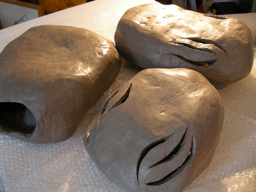
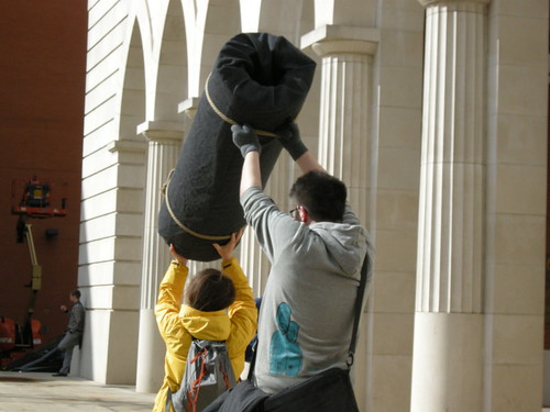
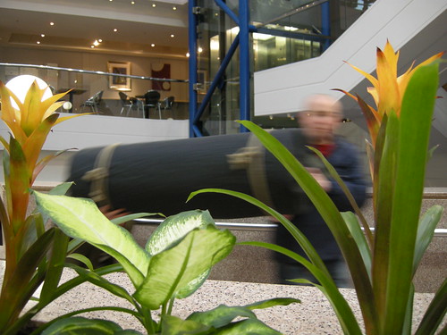
    The finished Dust Balls

    There’s a whole other post-worth of talk about the whys, wherefores and processes relating to the clay, but this post is about what went inside the Dust Balls.

    Short answer: lots of electronics.

    Dust bunny brains

    Location, location, location

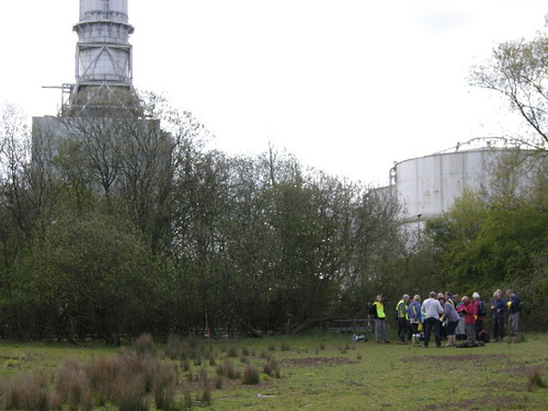
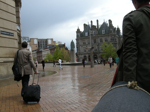
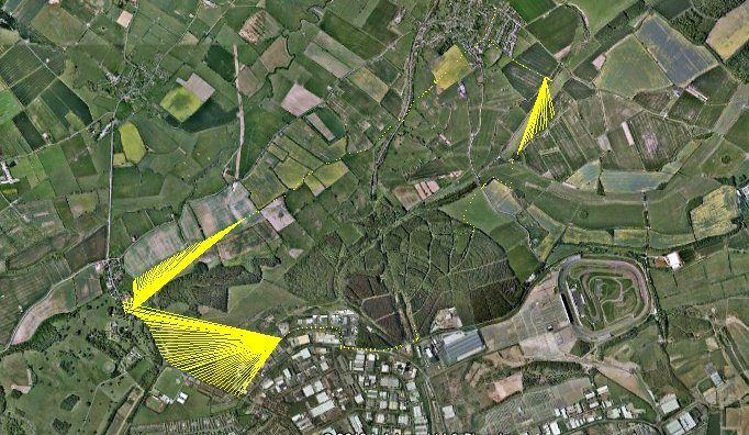
    Once we’d decided to site the Dust event on top of the Vyse Street car park, I spent several hours up there over 3 or 4 visits after work. We didn’t have much in the way of lead-in, but this was time well spent getting to know the feel of the location and details such as how loud the ambient noise of the traffic below is, how busy the car park is at that time and generally getting to know the lie of the land.

    View from the top deck of the car park towards Snow Hill station and Colmore Square.

    From here we were able to locate the 5 story threads that Hannah had written amalgamating objects and memories submitted by different contributors.

    Thread 1: a visitor to Birmingham is reminded of being in love; Thread 2: a man feels like a boy as he listens to a recording of the grandfather he never met; Thread 3: an office-worker battling deadlines and spreadsheet puts a hand to the pocket containing one of his son's toys; Thread 4; a victim runs through the city streets at the feet of the tower blocks; Thread 5: a friend bearing a gift walks purposefully towards the hospital.

    Working from a tracing from a fold-out A-Z map of Birmingham, I drew out the segments for each thread and used a protractor to get the bearings for the boundaries between threads. This working diagram was then orientated to North and taped to the table-top in preparation for testing the the next stages…

    Locating story fragments

    The compass module

    After some research into different options, I decided to use this CMPS10 tilt-compensated compass module. The tilt compensation was important (since we couldn’t guarantee the Dust Balls would be held horizontally) but it was also selected because of the range of communication methods (serial, I2C, pwm) and the documentation and example code available. Given the lack of time and my lack of coding chops, this is the sort of bet-hedging that was required!

    Compass module

    It was easy enough to get the compass module working with an Arduino using the example code. I initially tried serial communication, but I couldn’t get this working via the NewSoftSerial library when I came to combine it with the mp3 shield.

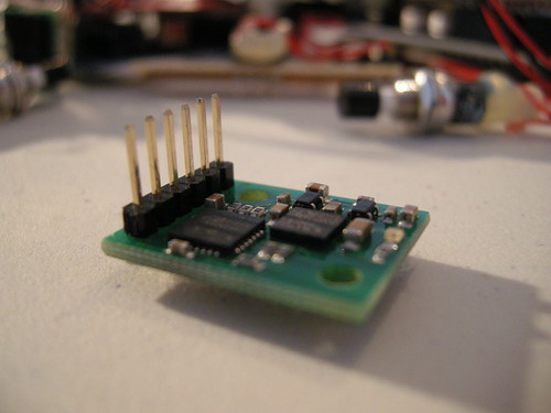
    The switch to I2C communication required the addition of a couple of pull-up resistors, which I made into a stripboard ‘shield’ that I could plug into the Arduino stack.

    I2C and reset 'shield'

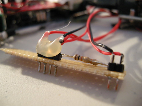
    This made things a bit more robust for placing them inside the Dust Balls, as well as being a nice convenient modular approach.

    I also added in a push-to-make switch between the ground and reset pins. This would allow me to place the the electronics at the back of the Dust Ball where they wouldn’t interfere so much with the compass readings, but to still have reasonable easy access to reset the kit between users.

    mp3 shield

    The remaining component of the set-up is the mp3 player shield. I used this one from SparkFun, and it worked, although I may well choose something different next time around…

    Dust bunny innards

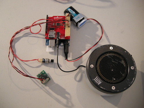
    The main thing to be aware of with this shield is the lack of a line out. There’s a headphone socket and somewhere to connect a speaker, but using an amplifier without also adding in protection against electrostatic discharge runs the risk of frying the audio chip. We’ve been lucky so far using portable speakers in the headphone socket, YMMV and you have been warned.

    When using these shields you also need to be careful to install the SDFat library correctly (only the ‘SdFat’ folder from the zip file) and ensure you make the necessary changes to the Sd2PinMap.h file as documented in the mp3 player example.

    The comments on the product page are well worth a read through too.

    Anyway, I got it working eventually…

    et enfin

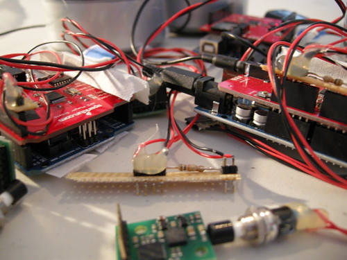
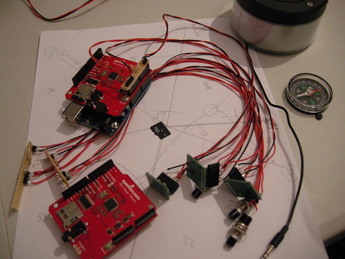
    The final stack looked like this:

    Stack: Arduino, mp3 shield and I2C/reset gubbins

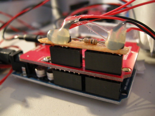
    Arduino Uno, mp3 player shield and homebrew I2C/reset shield, also connected to the compass module and the portable speaker. All powered with a PP3 9 volt battery connected to the Arduino’s power jack.

    I added in some hot melt glue to protect the soldered joints that were prone to flexing and breaking and also used black insulation tape to cover over some of the power LEDs (I didn’t want the Dust Balls to look like they were powered by Kryptonite!).

    Strips of velcro were used to hold the components in place during use, whilst still leaving them removable when required.

    The code takes its main functionality from the compass and mp3 player examples, with some logic to select which audio track to play depending on which direction you’re facing and what’s been played before.

    As ever, there’s room for improvement, but hopefully there’s enough here to get you started with your own projects. There’s also a set of photos from the make on Flickr.

    We will not be afraid to get our hands dirty.

    We will make and share our own tools as appropriate.
    We will collaborate.
    We will be generous.
    We will be porousexcerpt from the Splacist Manifesto 2.0


    Copyright and permissions:

    General blog contents released under a Creative Commons by-nc-sa license. Artworks and other projects copyright Nicola Pugh 2003-2024, all rights reserved.
    If in doubt, ask.
    The theme used on this WordPress-powered site started off life as Modern Clix, by Rodrigo Galindez.

    RSS Feed.