Why I’ve been talking about Eastside a lot recently

In September 2006 I made some work for an arty bit (the Anti-Talent Zone) in Channel 4’s TEN4 magazine (Issue 4: The Talent Issue). I’ll let curator Gavin Wade do the introductions:

In the Anti-Talent Zone anything goes, there are no laws, no morals, no identities, no property, no art, no profits only lots of pain[…] At the heart of the Anti-Talent Zone you will find an emptiness organised by Nikki Pugh[…] Pugh has wiped clean a section of our glorious city currently in the grips of a reality adjustment adding one new name to the mix. The site of Hewitt Street in Manchester, home to a successful contemporary art scene originated by local artists, is also the model of growth for Birmingham’s Eastside as overheard by Pugh in the halls of power.

welcome to the Anti-Talent Zone

The Arts Council and UCE’s (now BCU) plans to build a Castlefield-esque artist led space on Bartholomew Street fell through, however Eastside Projects (fronted by one Mr. Wade!) opened on Heath Mill Lane late last year. But what of the rest of the Cultural Quarter Digital District regeneration area? [Don’t worry: I’m not going to attempt to answer that!]

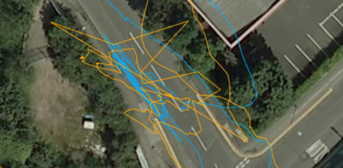
Meanwhile, back in February of this year I started doing a lot of GPS work in Digbeth. I noticed my equipment was giving me inconsistent results in a way that was quite interesting and planned to use this in its own right in a different piece of work.

For various reasons it seems fitting to go back and revisit the Eastside regeneration area with my slightly shonky GPS units. A few new shiny buildings have appeared in the 3 years since the Anti-Talent Zone, but reality has a habit of resisting adjustment and much of Eastside is still as I remember it. Though, perhaps the point is that I was mostly oblivious to all but a few corners of that part of the city…

I’m fairly familiar with the streets around the Custard Factory, and the Bull Ring/High Street just sneaks into the zone, but Eastside is a massive slab of what is, to me, generally uncharted territory.

Birmingham City Council's Eastside regeneration area

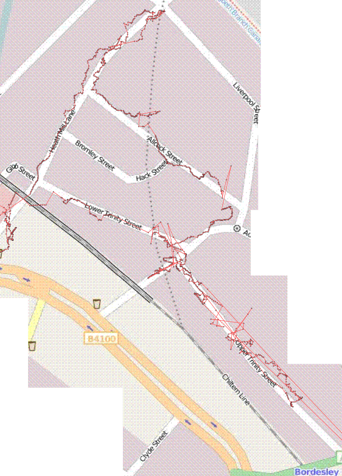
Spurred on by the glorious early Autumn weather we had last week, I finished tinkering with the code that logs the positions read by my GPS units and I started investigating the mysterious Eastside. At the moment I’m concentrating on the outer edge. I’m at once amused, baffled, frustrated, and in concordance with this demarcation: it makes perfect sense in terms of following the existing lines of major roads etc, but I’m galled by the idea that what was once intended to be the ‘Cultural Quarter’ (I don’t know if that’s still the case) can be defined by a staked out territory and then filled in. Of course departments and policies need to name and define, but I have trouble mapping that onto creativity and culture which I conceive of more as bubbling out from particular points where circumstances collude to allow things to transpire…

Anyhow, I’ve walked the boundary 3 times now and it’s fascinating to observe and ponder on the various fluxes taking place. In addition to the swathes of land being bulldozed and the flows of people either by car or on foot, I’ve also been thinking a lot about how this work relates to firstly my Anti-Talent Zone criticism of parachuting stuff into an area and, secondly, one of my Counsel for the Artist statements: make exchanges with spaces. That’s why I’m repeatedly walking the boundary, rather than just doing it the once. Since each orbit takes between 90 and 120 minutes to complete, that’s a lot of contact time – albeit of a transitory nature – and I can attest to the process starting to leave its mark on me.

As a by-product of compiling the GPS traces (I’ll post some images of those separately I’ve posted some images here) I also felt compelled to record something of what I’m seeing by way of documenting this moment in Eastside’s evolution. This feeling is particularly strong walking along the Dartmouth Circus and Lawley Middleway section of the boundary, where there is a lot of demolition taking place.

Here is a slideshow of some of my photos. What will I see when I walk this walk again in 3 years’ time?

drift

I’ve been doing lots of GPS legwork in preparation for a piece of place-specific work I’m developing for a section of Digbeth.

Basically this means walking a fixed route many times whilst carrying a GPS device so I can then look back at the trace of where it thought I went and get a feel for how much the buildings deflect the GPS signal. The things I’m particularly interested in (sorry – can’t be too specific at this stage!) are extremely liable to do this, so let’s just say I’m spending a lot of time walking around Digbeth at the moment!

Each walk takes approximately an hour to complete: I walk up and down particular roads, always staying on the right hand side and walking in the middle of the pavement (or as close to it as I can get seeing as how the pavements are often substitute carparks in Digbeth).

A few days ago I did a nice walk in the sunshine, but it was sullied somewhat when I got home and processed the traces – only the first 400m or so of my walk had been recorded! After that I decided to take both of my devices out with me, so I had a safety net if one of them didn’t record properly.

Yesterday I walked with a device in each hand:

iPAQs and gum

Check out those gum constellations! nice.

As I walked, I noticed that the device in my right hand was consistently giving me more erratic readings for my position than the one in my left hand. At one point I left them both next to each other on a wall for a few minutes so that when I could tell if it was my body disrupting the signal, or if it was because the device in my right hand was closer to the buildings I was walking past.

side by side

jitter

As you can see in the above screen-grab, there’s still a lot of discrepancy.

This got me thinking: by taking two devices out with me, I now had two traces that could be synchronised because the data that’s logged also includes time.

With a bit of fiddling around in notepad and calc I was able to merge the two sets of data and combine it with some mark-up so that that rather than having a line per device that joined position at time1 with position at time2, I could generate a series of lines that joined position from device1 and time1 with position with device2 at time1. Approximately.

Here’s a screen grab:

pretty!

Most of the lines really aren’t that short though and Digbeth is criss-crossed with a mesh of yellow. The best attempt so far at describing it comes from Tom Maillioux:

Like you reprogrammed your GPS to make not just a point, but a line from everywhere you were, showing all the places where you COULD have been.

I love how this has turned the data-collection into a drawing project and how it’s resonating with aspects of psychogeography, belief in technology and the whole sort of indecisiveness of Digbeth.

Now all I need is a way of extracting those lines from the .kml file so I can print them out big.

exporting mscape traces to Google Earth

I’m not very familiar with either GPS or Google Earth so this took me a lot of trial and error – there’s probably room for some refinement!

Problem:

You have used mscape to log your GPS route, but the overlay trace function within mscape isn’t useful for comparing multiple traces or for sharing with others.

One possible solution:

Strip your log file

Open your log file and save a copy somewhere else to work with.

I’m generally working with coordinates in decimal degrees in Google Earth (Tools > Options… >3D view), so that’s the format I want my log data in.

Open the file in notepad (or other text editor) and check your data is in the right format. Here’s a sample line for Birmingham, UK (wrapped):
21:05:32,Place,centre_and_digbeth,E,OnLocationChange,
52.4545033333333,-1.892005

We need to strip out all the first part so we’re only left with the coordinates.

Open the text file (you did save a different copy to work with, right?) in Calc or alternative spreadsheet application. You’ll need to open it as text CSV so make sure you select that file type after selecting the file you want to work with:

text CSV

The next window will give you some options. Check the box to select comma as a separator and double-check in the preview below that this splits your data up into the appropriate columns:

comma

After the file has opened, select columns A-E and delete them:

delete columns

This will leave you with just your longitude and latitude data in columns F and G. They’re the wrong way around though so we need to select column G and cut and paste it into column A, and then cut and paste F into B:

For me, calc defaults to showing numbers to 2 decimal places, so I right click and format cells to bring it up to 14 decimal places which is how accurate my log data is:

14 decimal places

(You may need to increase the column width to display the full number rather than ###.)

We now have data that we can insert into a .kml file for Google Earth. Nearly.

data

Save your spreadsheet as a .csv file, making sure to check the “edit filter settings” box at the bottom:

save as CSV

In the next window make sure you’re using a comma as your field delimiter and then save.

You can now open up your .csv file in notepad. It should look something like this:


-1.89200500000000,52.45450333333330
-1.89200500000000,52.45450333333330
-1.89200500000000,52.45450333333330
-1.89213000000000,52.45448500000000
-1.89213000000000,52.45448500000000
-1.89213000000000,52.45448500000000
-1.89210666666667,52.45450333333330

This is what you will carry over into your .kml file.

Note for UTM data:

Some of my logs are in UTM format, (I think it’s something to do with importing a pre-existing maplib file, this may help) in which case they look more like this to start off with:

20:32:17,Place,centre_and_digbeth,E,OnLocationChange,
575850.093317163,5814462.83102075

(You can check what you’re aiming for by hovering the mouse over your location in Google Earth and reading off the coordinates at the bottom of the window.)

To convert from UTM to decimal lat/long I used the batch convert sheet of this spreadsheet from Steven Dutch. In the case of Birmingham (and most of the UK) set column D cells to all have a value of “N” and column E (aka UTM zone) to “30”. You’ll then have to copy your data into F and G and extend the formulae down on either side to the appropriate length.

I then had problems trying to copy and paste the results into a different file because the cells were still trying to reference cells in the first spreadsheet for the formulae. My eventual work-around was to save as a .csv file and then open it again before copying into a different file, switching the column positions and then taking it into notepad.

The .kml file

Working from the examples here, I got my basic .kml structure down to this.

Save that file and then you can open it up in your text editor.

Copy and paste your coordinates into the gap between the tags near the bottom and then fill in the titles and descriptions as appropriate.

Save and then cross your fingers as you open the .kml file in Google Earth!

huzzah!

GPS signal stability in Digbeth, Birmingham

digbeth walk

It’s not that grate, akshully.
(click for map of full walk.)

mscape for randomised story-telling

Just before Christmas I responded to a call for artists from a Primary school looking for ways of

  • Making use of the “outdoor classroom”
  • Exploring the creative potential of ICT
  • Enhancing literacy teaching and learning
  • Actively involving pupils in documenting their own learning journeys
  • Supporting reflexive practice

I think I had my application in – suggesting application of mscape – within an hour of first getting the notification email.

Experience has shown that it can be a bit tricky explaining the principles of the software to people who are not familiar with the technologies involved. Talking sticks to the rescue.

In preparation for meeting with the project coordinators this morning, yesterday I prepared a quick demonstration mediascape to hint at how these things might be used as an impetus for creative narrative. (I’d never been to the school before, and so didn’t attempt to try and create something specific to the location).

demo

Although it was only intended as a quick demo, I’ve become quite taken by the idea so I’m blogging it in case anyone’s interested in providing motivation or situation for putting it into practice. :)

It’s a very simple set-up in terms of the coding involved: just a series of regions placed around the (in this case) school environment with onEnter/onExit events that trigger an alarm that randomly selects a sound file for addition to the playlist.

The interesting bit came when trying to decide what the sound files should consist of.

The context I’m imagining is a small group of pupils carrying a talking stick-esque device around with them as they set off on an improvised adventure around the designated area. This could be based on a classic journeying quest; be it to find an object or explore uncharted lands. Our intrepid adventurers move around in real space, but use their imaginations to reinterpret their surroundings and invent new things within it.

The role of the talking stick-esque device is to randomly interject prompts that the adventurers must respond to in real time within their narratives: if the stick yells out a warning to “hide!”, then hide they must; if the stick wonders if anyone lives here, then they should assess the surroundings and decide if it’s a suitable habitat for whatever characters are in the story…

Here are the prompts I used for the demo: (Many thanks to @goodhen whose response to my twitter request added a large number of these to the list.)

Look out! | What was that noise? | who’s this? | And so, off they went | oh no… | Good news! | Don’t move! | Shhhhh! Listen | What’s that over there in the distance? | Is anyone else getting that strange feeling? | Whatever you do, don’t make any sudden movements… | I think we need a change of plan | Be careful | Quick! What are we going to do? | What’s that smell? | Is there something hiding in there? | What was it he said again? | Quick, run for it! | Hide! | What should we do next? | Is it safe? | Look! Up in the sky! | Oh! That reminds me! | What *is* that?! | I feel weird. What’s happening to me? | I’m hungry | huh, is that an elephant? | I don’t believe it! | Of course! | I knew that was going to happen | oh, wait a minute | hang on | are you sure this is a good idea | what do you think will happen? | [Gasp] | ouch | do you think anyone lives here? | Is it a message?

What type of prompts inject the narrative with the sort of elements that make for a gripping narrative and what sort of prompts inject the narrative with opportunities for pupils to develop the sorts of skills their teachers might be looking for? And are these things different? …oh, and how can they instigate interactions with/responses to the surroundings too?

Also for consideration: How to start off the story – should you set a particular scenario and then can you tailor your prompts to that? Would it work equally well with trigger regions placed randomly, or should they relate to the ‘interesting’ features of the landscape? With more knowledge of yarn-spinning, would it be a good idea to add conditional logic to the prompt selection such that if x has already been played, then do/don’t play y?

landmarks

About 6 months ago I started getting very interested in how people navigate their way around a particular part of the New Forest.

common

Having now been to The Other Canada I returned to Canada Common a couple of times over the last week or so with the beginnings of an idea to collate the material I gathered from the dog-walkers into a mscape-driven thingy that then presents you with different guidance and instructions depending on where you are and which direction you are heading in.

I still haven’t decided on exactly how I’m going to tackle it, so I just took the opportunity to observe and ponder, trying to place the information people had given me back into the landscape it referred to.

The the GPS trace shows that, despite the cold weather freezing most of the water on the common, there were still a few parts I struggled with (for example, the S shape in the middle of this image as I try and decide how best to cross a small stream!)

trace

[note to self: must take a look at how to import the log into Google Earth – I don’t like all those artefacts that appear on the images imported into mscape]

I have to say though, the best tracks laid that day were the snuffly ones made by the ponies.

snuffle tracks

This video shows the landscape I’m investigating in 2 revolutions: the first with no markers; and the second with labels indicating some of the landmarks people use to navigate by [warning: not suitable for those prone to sea-sickness].


landmarks from nikkipugh on Vimeo.

A few photos from the walk:

ice

plant

web

bog

feet

can you get there from here?

This afternoon I went out to a nearby and conveniently large, open area of common to test a new version of the code for the project I started last month.

overlay in Google Earth

The code works a treat – which is great – but I can confirm the experience of using it is rubbish without the sticks and someone else to play with.


Can you get there from here? from nikkipugh on Vimeo.

Percussion for Hill and GPS

Here is a [completely non-representative] taster of what was coming out of the cardboard boxes:


Percussion for Hill and GPS from nikkipugh on Vimeo.

The drumming and breathing was commissioned from Adam Kinner (the saxophonist from this post). He’s recently started a blog and I definitely think it’s one to watch for the future. Go have a look-see.

17 ways…

A (silent) video accompaniment to the previous post:


17 Ways… from nikkipugh on Vimeo.

Manifesto for mediascapes

During the Almost Perfect residency, I had the chance to try out a few different types of thingies running off the mscape platform, but towards my 4th week in Banff I was starting to question the typical delivery format of iPaq and headphones. I couldn’t see how wandering around on your own, gingerly holding a foreign touch-screen device whilst plugged into headphones and being isolated from your surroundings related to my practice.

Nothing against those other mscapes I experienced, it just wasn’t a canon I wanted to contribute to.

Here’s what we were using to run the mscape player off:

iPaqs

A sight that might make some techies salivate, but kind of intimidating at the same time. These would generally be used in conjunction with some fairly substantial headphones. As a result you could very easily be worrying about if you’d pressed some of the wrong buttons, accidentally nudged the touch screen or whether you were easy prey for some street crime …rather than concentrating on whatever sounds were being delivered to via the headphones.

Things started to get interesting when people paraded down the street en masse but, for the most part, the experience stayed with the person wearing the headphones.

Cue my manifesto for mediascapes:

manifesto

Be visible (i.e. make it obvious that something is happening, rather than skulking around wearing headphones and looking at a small screen); and be audible (inflict your happening onto innocent passers-by).

These starting points later opened out into further thinkings about how to make mediascape experiences shared experiences and how to make mediascape experiences playful experiences.

How these thoughts manifested themselves was through a quick prototype alternative housing for the iPaq.

First I hacked (in the non-tech sense) apart and rewired some mp3 player speakers and then I mounted them inside a cardboard tube.

wires

distort

I then had something big with a strong physical that you were very aware of carrying; something a bit shonky and made from very familiar, very non-intimidating materials; something that was loud; and something just a little bit ridiculous. A tool, a plaything, a conversation starter.

Actually, I had two.

With a diameter of influence of about 20 metres each.

With two of these ‘talking sticks’ I had a way of encouraging interaction between people using the mediascape. We also started up a few conversations with people who had no idea what was going on …but wanted to find out!

interact

Like when Emergent Game‘s egorbeaver made friends with the ticket inspector or when Paul and some other Digbeth Invigilators found themselves in the position of having to make sure an inebriated stranger got back to her hotel safely I find these instances of when a thing bleeds out of its original context and reaches another layer of participant very interesting.

It was also fascinating to see how changing the interface for the mediascape changed the way people conducted themselves. Admittedly I don’t have a huge amount of experience with mediascapes, and wandering around the corners of campus listening to piano strings being broken is probably going to foster a fairly light-hearted reaction, but there’s something different going on here, right?

w00t

grin

clasp

careful now

hands

climb

jim

huts

sweep

scramble

stroll

baguette

play

[Update: And there’s some video footage here too.]


Copyright and permissions:

General blog contents released under a Creative Commons by-nc-sa license. Artworks and other projects copyright Nicola Pugh 2003-2026, all rights reserved.
If in doubt, ask.
The theme used on this WordPress-powered site started off life as Modern Clix, by Rodrigo Galindez.

RSS Feed.