On making things

I came across this short documentary this morning:

We Make Things. from Ryan Varga on Vimeo.

Here are my resonant points:

  • Technology as the tools we use to communicate with other people.
  • Making technology accessible is: looking at something, knowing it, understanding it, taking it apart, putting it back together, remaking something new.
  • Understanding the technology as having come from somewhere: as having an origin, as being made.
  • I do a lot of work with technology, but I’m not actually interested in technology – I’m interested in people.
  • Technologies of various kinds have the power to change our relationship to the world, to other people.
  • Not having to allocate technology to an expert. Community is the biggest thing that’s motivating. The tools themselves are boring.
  • Development practice in some ways is as meaningful politically as protest and voting.
  • The maker movement is portrayed as something that’s new, but it’s not: it’s a return to knowing how things work.
  • We’ve been through this era where things got kind of abstracted and sealed off, where we weren’t looking at them. [The technology inside things.]
  • It’s very hard for people to connect with a mentor – with a master, if you will – and the information share from generation to generation …we’ve let technology get in between that.
  • The separation of language and action. When we describe something linguistically, it’s very easy for us to form what that thing is and it doesn’t necessarily resist us very much. When we make something, the thing we make doesn’t always do what we want it to do.
  • When we’re doing critical making we’re not doing craft. We use making, not to come up with some kind of object for display, and not to come up with some kind of product to be sold, but as one way of guiding a shared experience. So we make together, and we think together, and we talk together…
  • The MakerBot is something that’s like, even though it’s digital, it’s kind of pulling us back to that to that time before the Industrial Revolution where people truly took time to figure out how things were made and what they were made from.
  • Objects with no traces of their production process are the wrong goal.We need to figure out ways to see the traces.
  • The great revolution: it’s not going to be people actually doing, it’s going to be that people understand what people that do, do

Those ideas around traces of the making process and understanding the origins of technology were in my head as I walked around Eastside this afternoon collecting data for Uncertain Eastside.

Blood. Sweat. Tears. Data.

It’s important to the work, and to me, that the two GPS units are carried around the city by hand, and that I push myself physically to do this (I do two circuits back-to-back, 7 and a bit miles). That those screens of numbers, of data, have an origin in human toil.

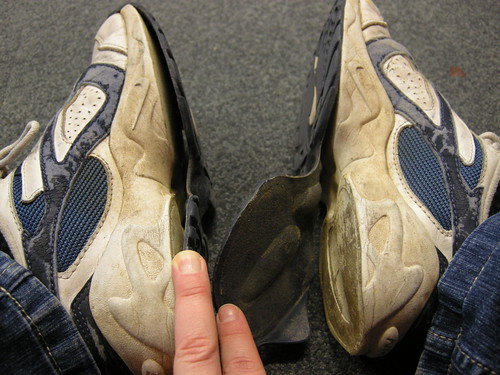
broken shoes

Disintegrating shoes (after a day gathering data around Nottingham)

update: And then, as if to prove the point, I processed the data from the day’s walking and got this, so I’ll have to do it again:

:( That's 7.32 miles I'll be walking again next week, then... #badGPSday

19,264 seconds of qualitative and quantitative data (Curzon Street, 2010)

What started as an exploration into my relationship as an artist to a proposed cultural quarter has expanded to also include a significant amount of sustained investigation into witnessing and documenting the change in that urban landscape.

Last year my focus was on the perimeter of Birmingham City Council’s regeneration area. Since walking and gathering the GPS data for Uncertain Eastside and organising the Walk and Talk event (in which we gathered lots of visual and anecdotal data) I’ve been increasingly aware of buildings going up and coming down in the area around Curzon Street and Millennium Point.

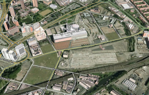
The Google Earth view of the area (with imagery that seems to be from 2007) is already drastically out of date, but it gives a rough idea about the range of contrasting terrain there now.

As well as spending hours walking all the streets in the zone I’ve selected, concentrating on paying attention to the details of the spaces, I’ve been collecting and processing GPS data to use as a measure of how developed the streets are. I will repeat this over the years to come as a way of logging the changes taking place on both macro and micro scales.

Google Earth view of the area I've been investigating

Google Earth view of the area I've been investigating

At the bottom left of the image above there is a relatively green area: old factory plots that have now turned to grassy wastelands and the park on the corner at the top of Fazeley Street.

Bartholomew Street, now closed to traffic and without any buildings around it. The bottom right corner shows where my path passes under the railway arches at the corner of Fazeley and New Canal Streets

Bartholomew Street, now closed to traffic and without any buildings around it. The bottom right corner shows where my path passes under the railway arches at the corner of Fazeley and New Canal Streets

Here the GPS data is fairly consistent. Water-heavy buddleia bushes overhanging the pavements on closed roads induce a few wobbles and railway viaducts cause momentary loss of signal, but on the whole the open terrain doesn’t interfere much with calculations of position.

Contrast this with the data gathered from around the various Further and Higher Education buildings on and around Fox Street and Grosvenor Street.

Tall buildings closely packed together reflect and block the satellite signal, causing the GPS calculations for position to be very inaccurate.

Tall buildings closely packed together reflect and block the satellite signal, causing the GPS calculations for position to be very inaccurate.

At one point one of the GPS devices calculated I simultaneously had one hand next to the halls of residence and the other on Digbeth high street opposite the coach station! (About 800 metres away.)

If even a small proportion of any of the various plans for Eastside are realised we look set to get more lines like this in the future.

I’ve come to refer to those two areas respectively as the Green Zone and the Learning Zone. The third zone in the area is the Rubble Zone – the plots between Millennium Point and the ring road that have been razed with the exception of 3 buildings: Belmont Row Co-op works, the lock keeper’s cottage and the Moby Dick’s pub.

From left to right: Cardigan Street, Gopsal Street, Penn Street and a tiny piece of Belmont Row. Currently mostly rubble.

From left to right: Cardigan Street, Gopsal Street, Penn Street and a tiny piece of Belmont Row. Currently mostly rubble.

The presence of all three of these buildings can be seen to affect the GPS traces. The image above hints at Moby Dick’s on Gopsal Street. For now the lines are uniformly short, but stand by for Eastside Locks. [link to pdf of proposed developments]

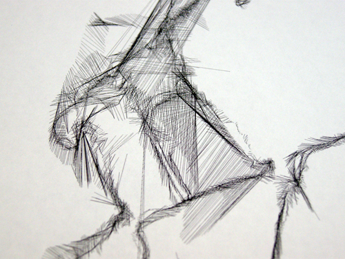
So there we have it: a snapshot of a part of Birmingham before it changes beyond recognition. Quantitative data gathered over several hours of walking a set pattern of streets whilst paying attention to the details, the changes and the people – I’ll tell you about it on a walk or in a pub sometime. Qualitative data in the form of 19, 264 lines that speak volumes if you know how to listen – probably a limited edition print coming soon.

19,264 seconds of qualitative and quantitative data (Curzon Street, 2010)

19,264 seconds of qualitative and quantitative data (Curzon Street, 2010)

The rain eased.

Google Earth view of the first 3 circuits of the area around Curzon Street

Google Earth view of the first 3 circuits of the area around Curzon Street

Poised. Waiting for the rain to ease.

route

The making of Location Aware

Last Friday I was in Nottingham making a new piece of work as part of the Territorial Play event organised by Trampoline.

Using the same dual-GPS process as for Uncertain Eastside, I selected a route that took me through a variety of different urban environments including narrow streets, open wasteland, alongside large buildings and around the foot of the castle.

Wasteland with desire lines

Wasteland with desire lines

Each circuit of the route (2.2 miles) took approximately 45 minutes to complete and started and finished at the Broadway Media Centre where the event was hosted.

We had a ‘project room’ that we were using as a base for various tech + mapping activities. After each circuit I returned here, processed the data and turned it into a .pdf file that my glamorous assistant Russell would take to the printers whilst I set out walking again.

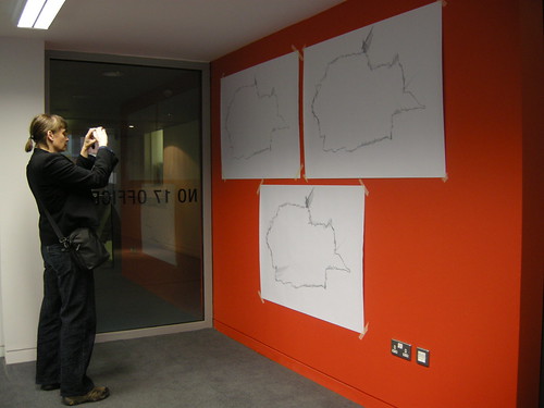
By the time I returned there would be a new print put up on the wall combining all the traces from all the previous walks.

Cumulative prints of the GPS traces

Cumulative prints of the GPS traces

I only had time for 3 circuits, but my shoes seemed to think that was plenty.

I’m really pleased with the results and had some great feedback and conversations with the other people at the event.

To share a little something of the resultant drawing – and how it relates to the landscape – I’ve added some details from the drawing to the Google Map of my route. Click on the yellow placemarkers to see the image and read the associated text.

Overview of the final route

Overview of the final route

Detail from the resultant drawing referenced to the part of the route it came from.

Detail from the resultant drawing referenced to the part of the route it came from.

So, head on over to the map: zoom in, zoom out, change views, click on things and have an explore!

Walking Route for Location Aware

I’m currently working on the route I will walk for my piece Location Aware at this Friday’s Territorial Play platform event in Nottingham.

The problem is, I don’t know Nottingham, so I’m crowd-sourcing some input on a route I’ve put together from Google Maps.

If you know Nottingham at all, then I’d be grateful for any feedback on this route (larger version here, or click though for zoom-able version on Google Maps):

My first proposed walking route - what do you think?

My first proposed walking route - what do you think?

I’m looking for the following qualities in the final route:

  • Safe for me to walk with a PDA visible in each hand.
  • Total walking length of about 45 mins (I think the current one is about an hour).
  • Passing through a range of different built environments and open spaces.
  • Starting and finishing at the Broadway Media Centre.
  • Some interesting places to see on the way. Several times during the course of the day!

I’ll be going to Nottingham on Thursday afternoon and will hopefully get a chance to investigate the route ahead of the first scheduled walk at 11am on Friday.

Prior to that though, if you can suggest any changes to make the route safer, more interesting or maybe just different, then I’d love to hear from you!

Location Aware at Territorial Play event in Nottingham

I’ll be in Nottingham this coming Friday and Saturday for the Territorial Play platform event and symposium as part of Tracing Mobility.

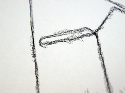
Detail from Uncertain Eastside - I will be using the same technique to explore Nottingham

Detail from Uncertain Eastside - I will be using the same technique to explore Nottingham

For Territorial play, Pugh will conduct a series of walks whilst carrying a satellite navigation device in each hand. Glitches in the technology and interference from the physical landscape result in anomalies in the data recorded by each device. As the journey is repeated and the resulting data overlaid, unique generative drawings are produced that reveal relationships between the fabric of the city and the behaviour of the technology.

My first walk will start at 11am and you are welcome to join me (free, there is a sign-up list at http://locationaware.eventbrite.com/), you can also join me on subsequent walks, through until the early evening, however these will be unscheduled.

The generated drawings will be on display at the Broadway Media Centre [Google map] and added to throughout the day as new layers of data are collected.

17 ways…

A (silent) video accompaniment to the previous post:


17 Ways… from nikkipugh on Vimeo.

Manifesto for mediascapes

During the Almost Perfect residency, I had the chance to try out a few different types of thingies running off the mscape platform, but towards my 4th week in Banff I was starting to question the typical delivery format of iPaq and headphones. I couldn’t see how wandering around on your own, gingerly holding a foreign touch-screen device whilst plugged into headphones and being isolated from your surroundings related to my practice.

Nothing against those other mscapes I experienced, it just wasn’t a canon I wanted to contribute to.

Here’s what we were using to run the mscape player off:

iPaqs

A sight that might make some techies salivate, but kind of intimidating at the same time. These would generally be used in conjunction with some fairly substantial headphones. As a result you could very easily be worrying about if you’d pressed some of the wrong buttons, accidentally nudged the touch screen or whether you were easy prey for some street crime …rather than concentrating on whatever sounds were being delivered to via the headphones.

Things started to get interesting when people paraded down the street en masse but, for the most part, the experience stayed with the person wearing the headphones.

Cue my manifesto for mediascapes:

manifesto

Be visible (i.e. make it obvious that something is happening, rather than skulking around wearing headphones and looking at a small screen); and be audible (inflict your happening onto innocent passers-by).

These starting points later opened out into further thinkings about how to make mediascape experiences shared experiences and how to make mediascape experiences playful experiences.

How these thoughts manifested themselves was through a quick prototype alternative housing for the iPaq.

First I hacked (in the non-tech sense) apart and rewired some mp3 player speakers and then I mounted them inside a cardboard tube.

wires

distort

I then had something big with a strong physical that you were very aware of carrying; something a bit shonky and made from very familiar, very non-intimidating materials; something that was loud; and something just a little bit ridiculous. A tool, a plaything, a conversation starter.

Actually, I had two.

With a diameter of influence of about 20 metres each.

With two of these ‘talking sticks’ I had a way of encouraging interaction between people using the mediascape. We also started up a few conversations with people who had no idea what was going on …but wanted to find out!

interact

Like when Emergent Game‘s egorbeaver made friends with the ticket inspector or when Paul and some other Digbeth Invigilators found themselves in the position of having to make sure an inebriated stranger got back to her hotel safely I find these instances of when a thing bleeds out of its original context and reaches another layer of participant very interesting.

It was also fascinating to see how changing the interface for the mediascape changed the way people conducted themselves. Admittedly I don’t have a huge amount of experience with mediascapes, and wandering around the corners of campus listening to piano strings being broken is probably going to foster a fairly light-hearted reaction, but there’s something different going on here, right?

w00t

grin

clasp

careful now

hands

climb

jim

huts

sweep

scramble

stroll

baguette

play

[Update: And there’s some video footage here too.]

In C for Open Road

open road

I always knew I wouldn’t be able to realise my full-blown ideas for a locative media version of In C whilst I was in Banff this November: there just wasn’t time to organise the tech, the musicians, the recording and the power issues.

Still, not one to be put off by technicalities, I set off for a walk and a low-tech version. In C for musicians, speakers, GPS and open road.

map and chalk

Armed with a map and some chalk I walked along a road that had been closed to vehicles for the Winter. Taking each of the motifs in turn, I walked until what felt like the appropriate moment to pause and draw the music onto the road’s surface.

really open road

I’m not sure how long I walked for or how far I travelled, only that I got up to the 17th motif before my chalk ran out. This, I decided, was the end point for the piece.

Only not quite.

My minor obsession with In C is tied up in with chance meetings, interactions and collaborations with various people outside the group directly involved with the residency I was on and, as such, somehow really underlines the true value of residencies such as these. I still had 4 more sticks of chalk (kindly donated by Laura, thankyou!) and decided that rather than continuing in a different colour, I should open things up to further collaboration from other people.

instructions

A kit containing instructions, the remaining chalk, the score for In C and a map was passed on to Dohi Moon – one of the In C musicians from the concert – for interpretation and, perhaps, adding another layer of chalk to the road.

kit

I’m not sure what happens next, I just wanted to give it back.

update: Dohi Moon has posted a photo of her interpretation.


Copyright and permissions:

General blog contents released under a Creative Commons by-nc-sa license. Artworks and other projects copyright Nicola Pugh 2003-2024, all rights reserved.
If in doubt, ask.
The theme used on this WordPress-powered site started off life as Modern Clix, by Rodrigo Galindez.

RSS Feed.