towards a listing of useful spaces

… we interrupt our planned schedule of strategies for progressive education to bring you this post about finding somewhere nice to sit down…

Right now I’m surrounded by people who are great at clustering together with other people to Make Stuff Happen. Some do it in their spare time outside their work, for others it is their work. All the time I’m hearing of people coming up against potentially plan-scuppering hurdles when they get to the stage of finding the appropriate space.

We spent months trawling around trying to find somewhere suitable for fizzPOP and now BARG‘s having a hard time to find a venue for a planned BARGcamp. On some occasions the solution has been for me to invite people into my home so we had a place to do stuff.

And that’s just my own experiences. Multiply that by everyone else who’s trying to organise events, meetings and coworking sessions and I think it’s fair to say that a lot of time and energy is being wasted on venue-finding when it could be spent on something more productive. We need to get more joined-up about this to save on all the leg-work.

Efforts have been made before in various places: Paradise Circus started a venues page, there have been attempts at mapping free wi-fi in Birmingham and it damn near killed off the first Emergent Game when I set players the mission of locating free internet access near them.

The free availability of Wi-Fi is often important, especially in the case of coworking, but there are other factors as well, including, but not limited to:

  • location
  • general atmosphere
  • who else is likely to be there
  • security
  • number of people it can accomodate
  • kitchen/kettle facilities
  • and the availability of cake

I suspect the intricacies of being able to list the features of different spaces in an easily contribute-to-able way and to allow for people to add comments giving information on more subjective aspects of different spaces will require something custom made. In the meantime though, we need to do a bit of work to figure out what exactly this tool is that we need.

Protovation Round One:

(protovation means I expect this to be not quite right, but when we find out why it’s not quite right we’ll know what Round Two has to be…)

I’ve rustled up a quick google spreadsheet with some of the things that people have already indicated they would like to know about potential spaces. You can either edit the spreadsheet directly, or you can use the form. (The form is also at the end of this post.)

Please can you help me put information about useful spaces in this form?

The idea is that the information should be useful, but we’re also sort of trying to break the form by finding things that don’t quite fit (that’s why I’ve started off with interstice). It’s started off with a coworking brum bias, but once we get that nailed we can start expanding it out.

Please check the spreadsheet first to see if the venue has already been added. If it has, then feel free to add any extra information; if it hasn’t then please start a new entry. If you haven’t got all the information, don’t worry – someone else can come along later and fill in the gaps. If you need a new space for a different type of information, just add a new column. It would also be nice if you could edit the form to include the new column, but failing that, just leave a note here and I’ll do it.

If you’ve found something that breaks the system in any way, please also add a comment on this post so we can learn from it.

Here are those links again:
spreadsheet
form
hashtag: #catel
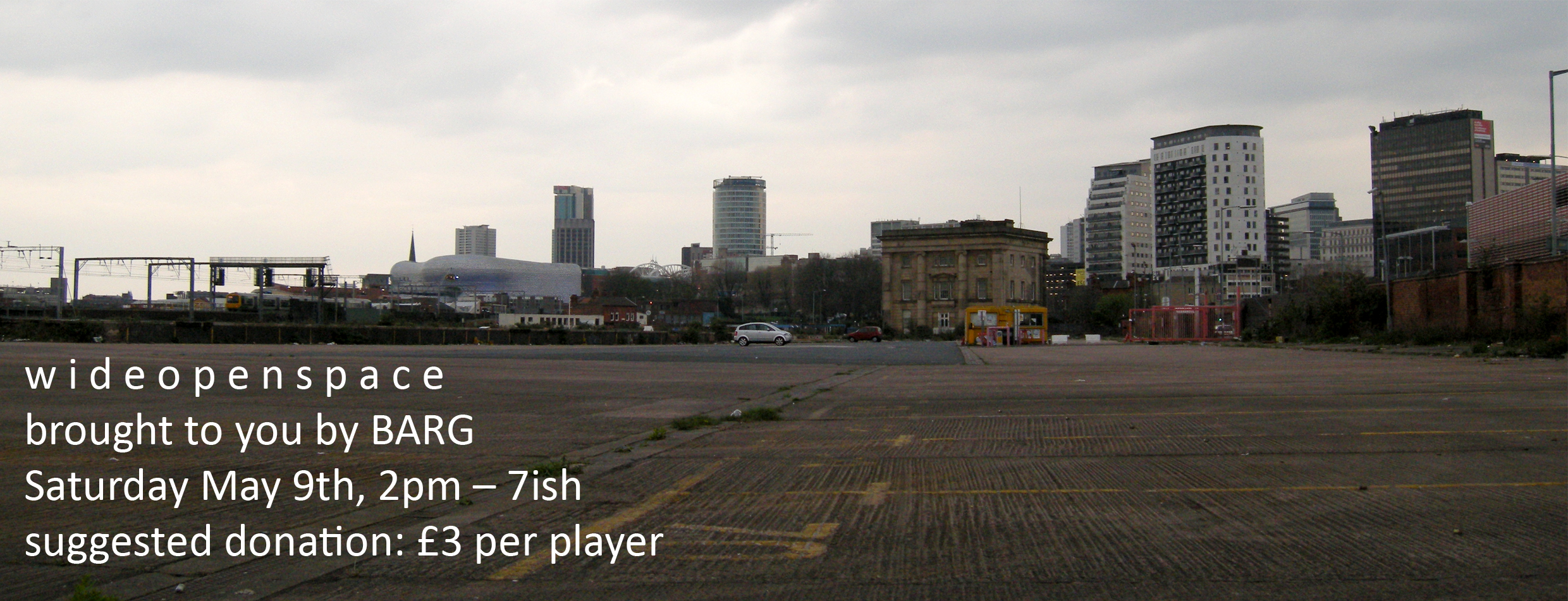
w i d e o p e n s p a c e

Edit 10th May: Scroll down to the comments to see links to documentation of the event.

w i d e o p e n s p a c e brought to you by BARG Saturday May 9th, 2pm – 7ish suggested donation: £3 per player

w i d e o p e n s p a c e is an afternoon of fun, games and picnics around the Curzon Street area of Birmingham. Come and explore the terrain and its possibilities with us. All are welcome although we ask that parents bringing children keep an especially close watch on them. We’re asking people to make a donation of at least £3 each to help fund future BARG events.

Sign up at http://is.gd/vqYz to let us know if you’re planning to join us.
A .pdf of this information is available for download here.

Programme:

Here are the games we’re planning to run. (But there will also be plenty of opportunities for you to invent your own!)

Hat Snap

(variant of a game designed by Krzysiek “Semp” Bielecki)
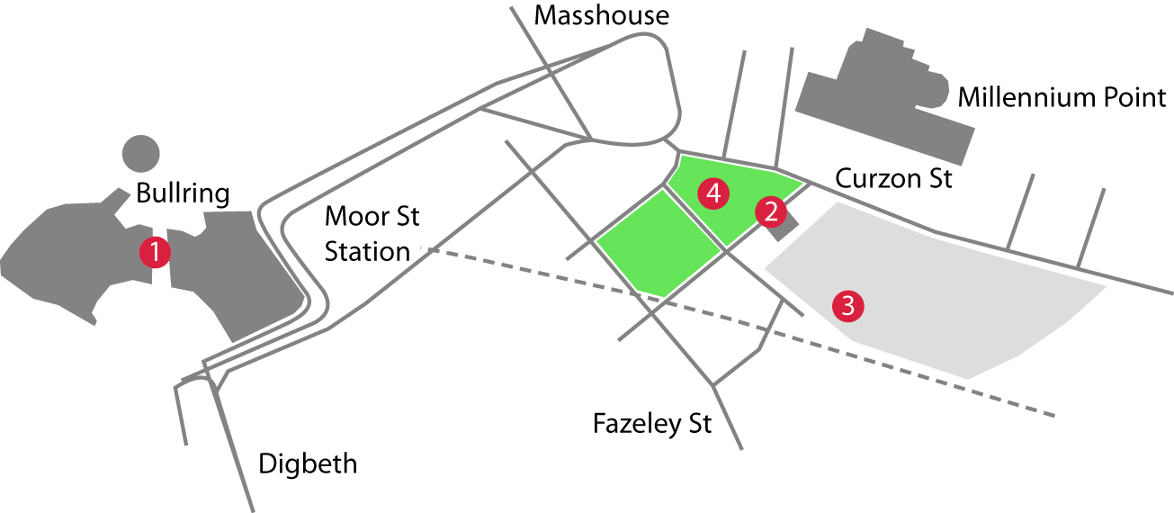
The first game runs between 2pm and 3pm, with sign-up in the Bullring shopping centre at the cube seats near Baguette du Monde and Café Rouge (the open-air bit between New Street and Saint Martin’s Square, [1] on the map, see below) between 2 and 2:20.

You will need to bring a digital camera or a camera phone and it will be to your advantage to not be carrying too much other stuff. If you’ve brought a big delicious picnic with you, you might want to sign up at the front of Curzon Street Station ([2] on the map) and leave your baggages with our stewards.

Players will rendezvous at the Curzon Street Station building at 2:40 to tally up the points and determine the winner ([2] on the map). Full instructions will be given to you when you sign up; it’s up to you to decide on your strategy…

The Lost Sport

(rediscovered by Jane McGonigal and Kiyash Monsef)
The Lost Sport of Olympia is believed to be a 2500-year-old game invented, and ultimately banned, by the Ancient Greeks.

At 3pm we will move to the Curzon Street car park (probably the bit at the back, between the skaters and the railway lines, [3] on the map) for a team game with no opposing team: listen carefully as your team-mates guide you around a labyrinth. Make sure you’re wearing shoes you can run in.

Picnic

(designed by you!)
Not a game, but still very enjoyable!

Bring some food and join us on the grass area in front of the station building between about 5 and 6 for a leisurely picnic ([4] on the map). Sharing of food and ideas encouraged!

Bocce Drift, Croquet and GPS Sketches

Grab a few friends and have play with these things that will be available after the carpark bit. The rules for Bocce Drift (designed by David Jimison and Jeff Crouse) are here: http://ludocity.org/wiki/Bocce_Drift and we encourage you to invent your own rules for croquet (bear in mind it’s a borrowed set though – please don’t damage it). As an additional challenge, we’re asking for people to bring along random (non-valuable/non-dangerous) spherical objects for some further games improvisation.

2 iPAQs will be available for you to use to record your movements around the area: what pictures can you make? After the event we’ll convert everyone’s tracks to a Google Earth file so we can see what people drew. (You’ll need to leave your credit card or driving licence as a deposit for the iPAQ.)

Human Snake

(designed by Minkette)
You’ve seen the game played on mobile phones, now it’s time to play it in real life. Conga around between 6:30 and 7 to collect the fruit before the other team gets it first.

The Weather

A game of chance.

In the event of bad weather, w i d e o p e n s p a c e will be cancelled. We will announce the final decision on whether it will go ahead or not by 11am on Saturday the 9th of May. The announcement will be made via http://twitter.com/pindec, http://twitter.com/genzaichi, here and http://bargbarg.ning.com/events/w-i-d-e-o-p-e-n-s-p-a-c-e so please be sure to check if the weather looks a bit dodgy.

In the event of good weather, please make sure you bring the appropriate hat/cream/parasol to stop yourself getting sunburnt – there’s not a lot of shade available around Curzon Street.

The Map

(Click to embiggen.)
wide open spaces

The Small Print

w i d e o p e n s p a c e is an exercise in exploring a part of the city that is currently something of a wasteground. We’ll be playing in unloved areas that may be littered with things like rubble and broken glass, so if you’re joining us we ask that you dress appropriately and be especially careful of your safety at all times. Play at your own risk, etc etc, but have fun and spare some time to look at the cityscape in a new way.

BARG is a Birmingham-based network for playful people who like to make and/or play interesting games.

A game for Curzon Street would…

the Curzon Street area

  • A game for Curzon Street would be designed for the Curzon Street area, and for the Curzon Street area only.
  • A game for Curzon Street would make reference to Curzon Street’s past. [wikipedia entry] [rail around Birmingham entry]
  • A game for Curzon Street would make full use of how Curzon Street is now.
  • A game for Curzon Street would make people explore.
  • A game for Curzon Street would make people interact.

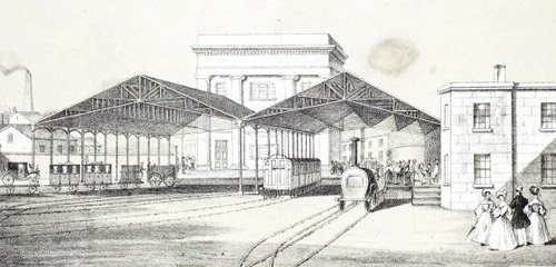
The London & Birmingham Railway, Curzon Street Station, 1838

Curzon Street car park

I’d like there to be a game designed specifically for this part of Birmingham.

BARG will be hosting an afternoon of play and picnics in the Curzon Street area (image of the full area) on the afternoon of Saturday the 9th of May. We can playtest either complete games or partial mechanics …or make something up when we’re there.

Consider that a challenge.

visitation

There’s nothing quite like hosting friends from another country for honing your observation skills.

As it happens, I didn’t take many photos during the few days we were together: we were probably too busy or something! Here are a few highlights from the visit and associated doings.

First up, at the suggestion of a Beatle-impersonating Jerome, we went to the Saturday Flea at the Custard Factory. Preparations were underway for an event in the pool.

back of the net

flatpack

We moseyed around bits of the Flatpack Festival and were very taken by the Floodgate Kino space. We stayed for the Knitflicks shorts and, having moved to stand at the back so as to be able to see the screen, I was suddenly struck by the realisation that I was sat in a warehouse with a hundred or so other folk watching films about thread. Excellent! The cake was nice too.

The exchange rate is very much in favour of my Japanese friends right now, so I was witness to a lot of shopping. I’m not saying I was bored or anything, but… I did notice this:

panda ambush

The Diwan was rammed [that’s right Mum, not crammed, but rammed. Same but different.], so we went to Ladypool Road and took pot luck. I can’t remember what it was called, (possibly a green frontage, just down from Dawat) but it got a big thumbs up for the curry and for the sweets. My favourite part was the restaurant version of the boogie-ing coke can.


Jiggling Jug from nikkipugh on Vimeo.

We opted out of Stratford-upon-Avon for reasons of cost-effectiveness, deciding instead to spend a few hours in Oxford on the way down South.

Pitt roof

I love the moment when you push open the heavy front door to The Oxford University Museum of Natural History and find yourself in the large, daylight-lit main exhibition hall. This time around (Red Nose Day) the central area was given over to slightly less terrifying beasties than usual.

terrifying beasties

Red-nose Rex

I like the way the one third back on the right is peering round to see how much longer he’s got to wait in line for.

bones

Elephant bones. Dumbstruck by how well they fit together.

perfect fit foot

perfect fit leg


Deoxyribonucleic acid from nikkipugh on Vimeo.

Having achieved down-south-ness we went to Lymington: fish and chips, a lot of time spent mooching in a chandlers and I also took the opportunity to introduce my friends to the way of the charity shop. I suspect we had a better time than the local pigeon population:

pigeon spikes

We parked at Keyhaven then walked along to Hurst Spit.

grasses

Climbing the spit to find ourselves next to the sea seemed to go down quite well:

beach jump

Map stone:

map stone


shingle running from nikkipugh on Vimeo.

line

View from near Hurst Castle across to the Needles on/off the Isle of Wight:

zig-zag and needles

Bricks are a thing of wonder if you’ve grown up surrounded by prefab and concrete. Realising now I forgot to present one as a souvenir. Damn.

brick

sliced sun

A two-hour walk at Deerleap with the part-time wild ponies. I spent a lot of time here doing my GSCE Geography coursework, but haven’t been back to for at least a decade. First time I’ve ever seen Bailey swim (admittedly it was only for about a foot, but that’s still progress)

Bailey

More jumping.

forest jump

We are the Interstitials

Foreword:

This post has been brewing for several days now and has just been tipped into existence by the latest post on Museum 2.0 about deliberately unsustainable business models. Other kindling includes: this comment from 2007 where I suggest some metallurgical references for renaming structural holes; Pete Aston’s tweet about being comfortable with the idea that he’ll be doing something completely different come 2015; and the job titles I variously use to describe to people what I do which include “transdisciplinary independent person”, “investigator” and “interstitial”.

We are the Interstitials is a metaphor based on principles of interstitial solutes in metals.

We are the Interstitials:

red interstitial in a grey matrix

We are smaller than the structures around us. We inhabit the gaps the host matrix cannot occupy itself.
Our small size gives us speed and responsiveness and though the sites we may occupy are ultimately determined by the host matrix, we are mobile and select which of the available positions we inhabit.

Our host is rigid; bound to the other similar entities around it in predictable patterns. We are independent; we may cluster around locations or other interstitials, but our interactions shift as required. We frequently move on, jumping between adjacent sites. There’s no problem, it’s just how we are.

Our host may regard us as defects, but though our numbers are small, our effects are wide-reaching and can drastically change the properties of the matrix we operate within. The energy-fields around us, induced by our presence, often make it easy for us to interact with other types of perceived ‘defect’, often impeding their motion or changing the way they in turn affect the matrix.

We are small, we are mobile, we affect. We are the interstitials.

drift

I’ve been doing lots of GPS legwork in preparation for a piece of place-specific work I’m developing for a section of Digbeth.

Basically this means walking a fixed route many times whilst carrying a GPS device so I can then look back at the trace of where it thought I went and get a feel for how much the buildings deflect the GPS signal. The things I’m particularly interested in (sorry – can’t be too specific at this stage!) are extremely liable to do this, so let’s just say I’m spending a lot of time walking around Digbeth at the moment!

Each walk takes approximately an hour to complete: I walk up and down particular roads, always staying on the right hand side and walking in the middle of the pavement (or as close to it as I can get seeing as how the pavements are often substitute carparks in Digbeth).

A few days ago I did a nice walk in the sunshine, but it was sullied somewhat when I got home and processed the traces – only the first 400m or so of my walk had been recorded! After that I decided to take both of my devices out with me, so I had a safety net if one of them didn’t record properly.

Yesterday I walked with a device in each hand:

iPAQs and gum

Check out those gum constellations! nice.

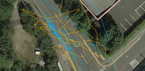
As I walked, I noticed that the device in my right hand was consistently giving me more erratic readings for my position than the one in my left hand. At one point I left them both next to each other on a wall for a few minutes so that when I could tell if it was my body disrupting the signal, or if it was because the device in my right hand was closer to the buildings I was walking past.

side by side

jitter

As you can see in the above screen-grab, there’s still a lot of discrepancy.

This got me thinking: by taking two devices out with me, I now had two traces that could be synchronised because the data that’s logged also includes time.

With a bit of fiddling around in notepad and calc I was able to merge the two sets of data and combine it with some mark-up so that that rather than having a line per device that joined position at time1 with position at time2, I could generate a series of lines that joined position from device1 and time1 with position with device2 at time1. Approximately.

Here’s a screen grab:

pretty!

Most of the lines really aren’t that short though and Digbeth is criss-crossed with a mesh of yellow. The best attempt so far at describing it comes from Tom Maillioux:

Like you reprogrammed your GPS to make not just a point, but a line from everywhere you were, showing all the places where you COULD have been.

I love how this has turned the data-collection into a drawing project and how it’s resonating with aspects of psychogeography, belief in technology and the whole sort of indecisiveness of Digbeth.

Now all I need is a way of extracting those lines from the .kml file so I can print them out big.

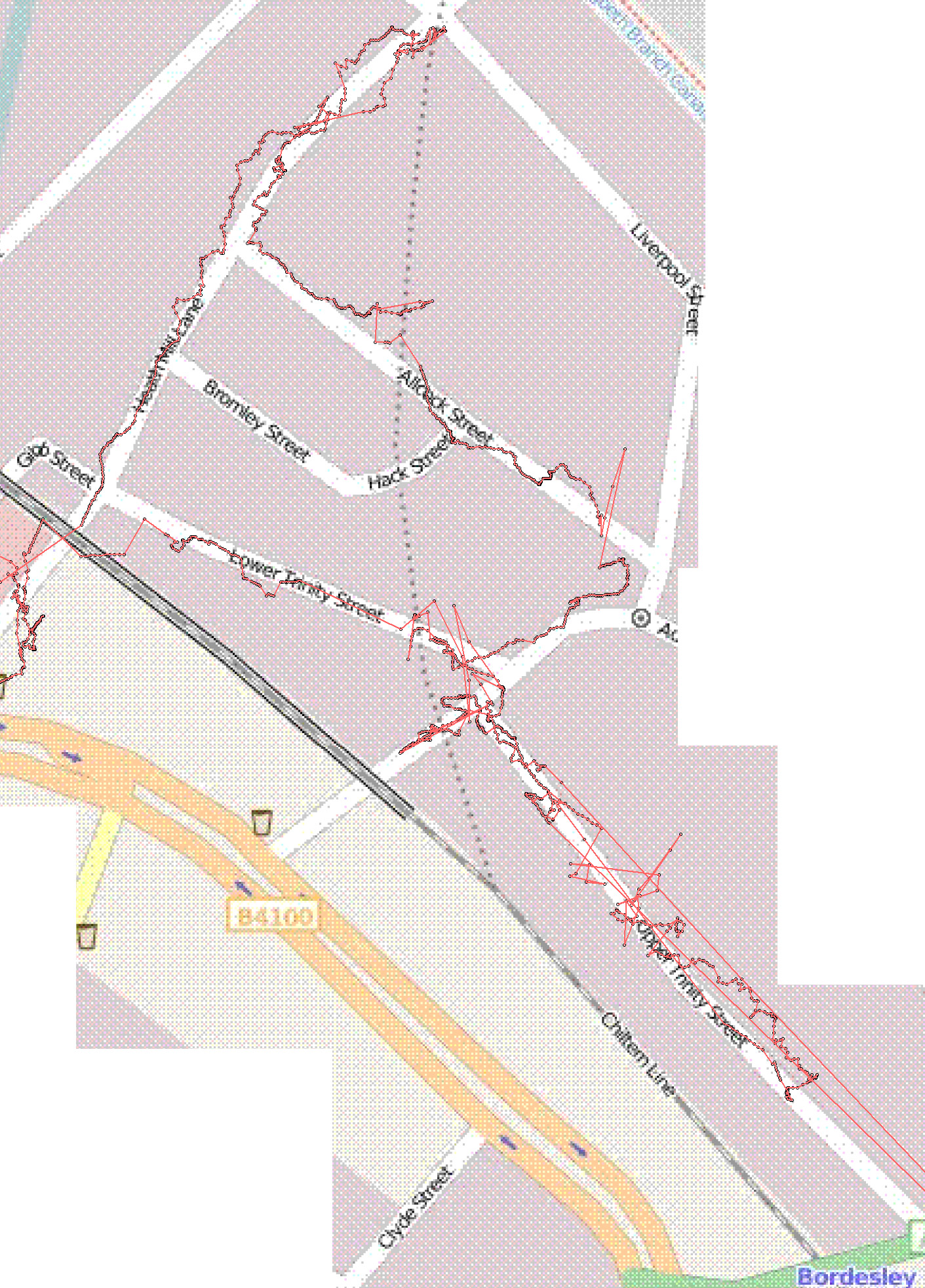
GPS signal stability in Digbeth, Birmingham

digbeth walk

It’s not that grate, akshully.
(click for map of full walk.)

mscape for randomised story-telling

Just before Christmas I responded to a call for artists from a Primary school looking for ways of

  • Making use of the “outdoor classroom”
  • Exploring the creative potential of ICT
  • Enhancing literacy teaching and learning
  • Actively involving pupils in documenting their own learning journeys
  • Supporting reflexive practice

I think I had my application in – suggesting application of mscape – within an hour of first getting the notification email.

Experience has shown that it can be a bit tricky explaining the principles of the software to people who are not familiar with the technologies involved. Talking sticks to the rescue.

In preparation for meeting with the project coordinators this morning, yesterday I prepared a quick demonstration mediascape to hint at how these things might be used as an impetus for creative narrative. (I’d never been to the school before, and so didn’t attempt to try and create something specific to the location).

demo

Although it was only intended as a quick demo, I’ve become quite taken by the idea so I’m blogging it in case anyone’s interested in providing motivation or situation for putting it into practice. :)

It’s a very simple set-up in terms of the coding involved: just a series of regions placed around the (in this case) school environment with onEnter/onExit events that trigger an alarm that randomly selects a sound file for addition to the playlist.

The interesting bit came when trying to decide what the sound files should consist of.

The context I’m imagining is a small group of pupils carrying a talking stick-esque device around with them as they set off on an improvised adventure around the designated area. This could be based on a classic journeying quest; be it to find an object or explore uncharted lands. Our intrepid adventurers move around in real space, but use their imaginations to reinterpret their surroundings and invent new things within it.

The role of the talking stick-esque device is to randomly interject prompts that the adventurers must respond to in real time within their narratives: if the stick yells out a warning to “hide!”, then hide they must; if the stick wonders if anyone lives here, then they should assess the surroundings and decide if it’s a suitable habitat for whatever characters are in the story…

Here are the prompts I used for the demo: (Many thanks to @goodhen whose response to my twitter request added a large number of these to the list.)

Look out! | What was that noise? | who’s this? | And so, off they went | oh no… | Good news! | Don’t move! | Shhhhh! Listen | What’s that over there in the distance? | Is anyone else getting that strange feeling? | Whatever you do, don’t make any sudden movements… | I think we need a change of plan | Be careful | Quick! What are we going to do? | What’s that smell? | Is there something hiding in there? | What was it he said again? | Quick, run for it! | Hide! | What should we do next? | Is it safe? | Look! Up in the sky! | Oh! That reminds me! | What *is* that?! | I feel weird. What’s happening to me? | I’m hungry | huh, is that an elephant? | I don’t believe it! | Of course! | I knew that was going to happen | oh, wait a minute | hang on | are you sure this is a good idea | what do you think will happen? | [Gasp] | ouch | do you think anyone lives here? | Is it a message?

What type of prompts inject the narrative with the sort of elements that make for a gripping narrative and what sort of prompts inject the narrative with opportunities for pupils to develop the sorts of skills their teachers might be looking for? And are these things different? …oh, and how can they instigate interactions with/responses to the surroundings too?

Also for consideration: How to start off the story – should you set a particular scenario and then can you tailor your prompts to that? Would it work equally well with trigger regions placed randomly, or should they relate to the ‘interesting’ features of the landscape? With more knowledge of yarn-spinning, would it be a good idea to add conditional logic to the prompt selection such that if x has already been played, then do/don’t play y?

landmarks

About 6 months ago I started getting very interested in how people navigate their way around a particular part of the New Forest.

common

Having now been to The Other Canada I returned to Canada Common a couple of times over the last week or so with the beginnings of an idea to collate the material I gathered from the dog-walkers into a mscape-driven thingy that then presents you with different guidance and instructions depending on where you are and which direction you are heading in.

I still haven’t decided on exactly how I’m going to tackle it, so I just took the opportunity to observe and ponder, trying to place the information people had given me back into the landscape it referred to.

The the GPS trace shows that, despite the cold weather freezing most of the water on the common, there were still a few parts I struggled with (for example, the S shape in the middle of this image as I try and decide how best to cross a small stream!)

trace

[note to self: must take a look at how to import the log into Google Earth – I don’t like all those artefacts that appear on the images imported into mscape]

I have to say though, the best tracks laid that day were the snuffly ones made by the ponies.

snuffle tracks

This video shows the landscape I’m investigating in 2 revolutions: the first with no markers; and the second with labels indicating some of the landmarks people use to navigate by [warning: not suitable for those prone to sea-sickness].


landmarks from nikkipugh on Vimeo.

A few photos from the walk:

ice

plant

web

bog

feet

can you get there from here?

This afternoon I went out to a nearby and conveniently large, open area of common to test a new version of the code for the project I started last month.

overlay in Google Earth

The code works a treat – which is great – but I can confirm the experience of using it is rubbish without the sticks and someone else to play with.


Can you get there from here? from nikkipugh on Vimeo.


Copyright and permissions:

General blog contents released under a Creative Commons by-nc-sa license. Artworks and other projects copyright Nicola Pugh 2003-2026, all rights reserved.
If in doubt, ask.
The theme used on this WordPress-powered site started off life as Modern Clix, by Rodrigo Galindez.

RSS Feed.